 | ||||
Notes about - Tracking the ISS
Earth spins counterclockwise from west to east. ISS 'precessions' have overlapping 'footprints'. Digipeater's 'footprint' radius to horizon is ~1000 ground miles (1610 Km).
Basic knowledge about ISS orbital motion and map reading will improve one's ability to work ISS packet. Most amateurs who can reach 2 meter terrestrial repeaters with good signal reports should be able to contact the ISS. Consider the ISS' 2 meter packet station as a rapidly moving 'repeater' speeding along at about 17,000+ mph (27,370+ Km/hr.) above the Earth's surface in a low earth orbit (LEO). It completes 15.7 orbits per day (each 93 minutes long) at an elevation of approximately 225 miles (362 Km). An operator must follow pass elevations, 'precession' of orbital ground tracks, 'footprint' coverage, and arrival times in order to access the ISS digipeater.
Packet exchanges are conducted in Ax.25 (unproto) 1200 baud format on a simplex frequency (145.825 MHz. FM). One doesn't have to worry about doppler offsets or multiple duplex uplink and downlink settings on UHF / VHF / HF that are required to work many of the other satellites. And even though motorized tracking antennas are beneficial, they are not rquired. With a vertical antenna, possibly a preampifier, and a mostly unobstructed view of the sky, good contact with the ISS should be possible.
Expect 'near' orbital passes to arrive in two 'groups' every day. The first group of 2-3 'precessions' arrives from one direction and is followed by the second group of 2-3 that comes from the opposite direction. Individual passes are 93 minutes apart. The second group arrives 1-10 hours later, depending on the latitude of the operator's station. At the highest and lowest latitudes of orbital extent (+/-52 deg. N orS), the 'groups' arrive back-to-back, but near the equator they are separated by 10-12 hours.
Pass Elevations influence digipeater access and Dx. High pass elevations are better for reliable digipeater access and low pass elevations may reach more dx. The digipeater is easier to access during higher elevation passes, (> 50 degrees) when the ISS is only 250-800 miles from the station (550-1,288 Km). During low elevation passes (<20 degrees above horizon), the ISS is nearly 1,000 miles (1610 Km) away. At that range, it is near the limits of reception, and more difficult to access. Dx contacts with stations 2,000+ miles away are possible during low elevation passes but may require more antenna gain and higher power. Pass elevations between 20-70 degrees are considered to be the best angles for both digipeater access and dx.
After some trial and observation, an operator will be able to 'visually' predict suitable passes on the maps. At The ISS Fan Club, there is a handy 'countdown' that shows the amount of time remaining until the next pass arrives at your location. The 'glossary of terms' found on the AMSAT site is a good place to start if you want to learn more about the ISS, satellites, and orbits.
Pass elevations determine how long a station can access the digipeater. Other factors that influence access include receiver sensitivity, antenna gain, and local line-of-sight obstructions. The maximum time may be 8-9 minutes during 'direct' 90 degree overhead passes. Lower angles will offer less time. Distant topography (mountains) or large buildings at the horizon may also block access when the ISS approaches from that direction. Stations must be ready to send short packet messages (and qso exchanges) as quickly as possible during these short 'windows' of access.
'Precession' (regarding the ISS) is the term that describes progressive westward change of the ISS' ground track as it orbits the Earth. After each subsequent 93 minute orbit, the satellite's longitude shifts (-) 22.5 degrees to the West. ISS 'precession' is the result of many factors, including orbital speed, orbital height, orbital inclination, and especially west-to-east (counter-clockwise) rotation of the Earth. Ascending and descending 'precession' tracks are the multiple lines found on ISS tracking MAPS that represent the different pass directions and elevations of each orbit.
Timing of anticipated passes is important. The daily ISS orbit 'arrives' approximately 45 minutes earlier at a fixed location every day. Timing of future orbital passes can be found on tracking sites. An operator must know future arrival times in order to plan ahead and be ready. Many sites have customizable parameters that allow the user to display a list of near passes showing elevations and 'arrival' times for that day and several days ahead. Some sites can even be configured to send future pass 'reminders' to the home computer or smart phone.
[ Mouse over ] ISS Real time Satellite tracking at the excellent n2yo.com site
(1) 5 day orbital predictions page (2) Individual ISS pass Data
| ||||
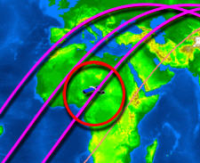
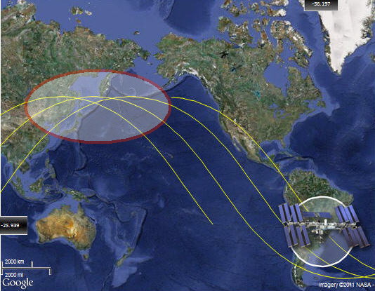
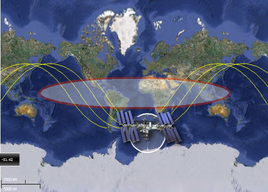
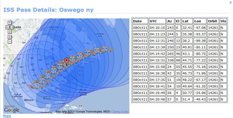
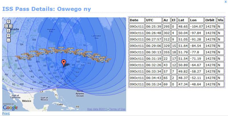
Left and Right Images: Examples of westward ISS ground track 'precessions' on consecutive orbital passes. The ISS is travelling in a NE direction on both maps. Circles represent the ISS 'footprint' which represents the extent of digipeater coverage over the earth's surface below.
Left Image: Nearly back-to-back consecutive passes come from opposite directions at +52 degrees N latitude every 24 hours
Right Image: Pass 'groups' from opposite directions are separated near the equator by 10-12 hours
(images c/o ISS Tracker.com)
- mouse over images to enlarge -

- The Practical Essentials -
Mouseover Image:
Relationship between Pass Elevation and ISS access time : During higher Pass Elevations the ISS is closer and gives more pass time than lower elevations (Example "El" = 68 degrees vs.7 degrees.)
Mouseover Image:
Examples of Dx opportunities: Passes North or Southwest of me have lower pass elevations but favor better Dx opportunities to Canada or the Western US-Southern US-Carribean, respectively. If both stations are inside the 'footprint', contacts are possible.
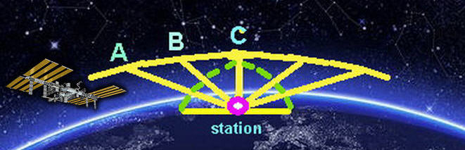
Relationships between ISS distance and Pass Elevations: At lower passes the ISS is farther away -
Distance from 'A' to station is (>) 'B' to station is (>) 'C' to station.
Current ISS position: The ISS passes over the equator with orbital inclination of 51.6 degrees. The upper half of the orbit is called 'ascending node', the lower half is the 'descending node'.
left Click grabs map